| For many living on the Florida Peninsula’s Gulf coast, the days leading up to Hurricane Milton’s landfall were filled with worry, anxiety, and uncertainty as the storm quickly became one of the most powerful Atlantic hurricanes on record. |
| Landfalling on the northern end of Siesta Key, Florida, at roughly 8:30 p.m. on Oct. 9, the then-Category 3 hurricane was still menacing, reaching wind speeds of 120 mph after topping out at 180 mph days prior. |
| At one point, areas from Florida’s big bend down to the Keys were in the National Hurricane Center’s (NHC) “cone of uncertainty,” which displays the possible locations where the storm could make landfall. |
| By Tuesday, however, that area was narrowed to the Tampa Bay region down to Lee County, leading to one of the largest mass evacuations in state history. |
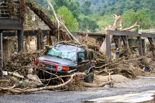
| With Milton gone, streets across Florida were turned green after its vicious winds ripped leaves from their limbs and trees from their roots. |
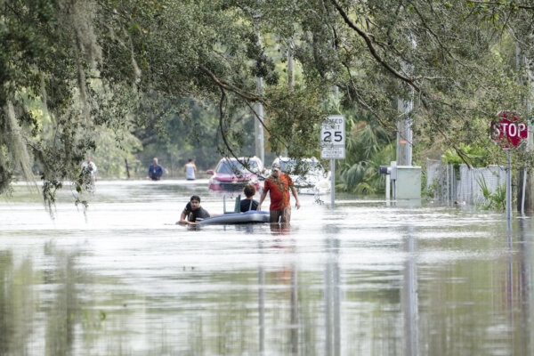
| Mobile home parks were gashed and deroofed, and standing water was left from the heavy rains and flash flooding. |
| Barrier islands, like Anna Maria Island in Manatee County, were shuttered but were slowly reopening to residents and the public. |
| “I think that this was the strongest winds that I’ve seen in the 45 years that I’ve been policing,” Holmes Beach Police Chief William Tokajer told The Epoch Times. |
| Holmes Beach is a town on Anna Maria Island. The Chief said the town will open to residents and business owners on Saturday. |
| While the storm was still destructive—spinning a record number of tornadoes and inundating areas from Sarasota down with 5-8 feet of storm surge—Milton came ashore weaker than initially anticipated, with some forecasts anticipating a Category 4 hurricane Wednesday evening. |
| That meant a reduced storm surge, or the onrushing flow of the ocean brought on by a spinning hurricane’s winds and low pressure. |
| For the west coast of Florida, that surge usually comes on the southern edge of the storm’s eyewall—as the center spins counterclockwise—pushing water to the east for any areas below the eye and pulling water away from the shore for areas north of the eye. |
| That meant Tampa Bay saw a reverse surge as water was sucked into the Gulf, while areas south of Siesta Key were directly in the water’s path—especially Venice. |
| Videos from Venice Island Wednesday evening showed streets inundated with upwards to three feet of water, particularly along The Esplanade roadway that connects W Venice Ave. to the city’s south jetty. |
| The thrashing Venice Beach took from Milton was clear just 12 hours later, as the parking lot was still under more than six inches of water. |
| Many of the nearby condominiums sustained water damage on the ground floors, with portions of building frames torn apart and strewn about like strips of cardboard. |
| In Charlotte County, which sustained considerable flooding damage along the coast, sheriff’s deputies rescued a paraplegic man who fell while trying to flee the rising waters with his wife, Chris Hall, public information officer for the Charlotte County Sheriff’s office, told The Epoch Times. |
| As of Friday evening, hundreds of thousands in the area are still without power. |
| “Until a survey is conducted to assess high water marks on structures, we really won’t know what the peak surge actually was,” which could be higher than 8 feet, Steven Morey, a professor at Florida A&M University’s Center for Coastal and Marine Ecosystems, told The Epoch Times. |
| The storm’s angle of approach could have affected the surge, but the actual cause is still unknown, a National Weather Service (NWS) representative told The Epoch Times. |
| Other hurricane experts told The Epoch Times that several factors affected the final surge levels. |
| “The water rise would have been greater if the peak surge came in at the time of high tide,” Corene J. Matyas, a geology professor from the University of Florida, told The Epoch Times. |
| Morey said Milton faced significant wind shear, which refers to changes in wind speed at various levels of the atmosphere, but also became asymmetrical ahead of landfall, with much of the energy concentrated north of the storm’s eye. |
| That energy tore the roof off Tropicana Field in St. Petersburg, with winds well over 100 mph. |
| The hurricane’s intensity, dimension, and track—coupled with coastal shape and structure—affect the intensity of storm surge as well. |
| “Small changes in the track can have substantial effects on the intensity of the storm surge and where those storms surge peaks will be observed,” Maitane Olabarrieta, a civil and coastal engineering professor at the University of Florida, told The Epoch Times. |
| That surge is usually concentrated along the south end of a hurricane’s eye, which, for Milton, includes portions of south Sarasota County down to Naples. |
| Regardless of the storm’s weakening, Milton claimed at least 17 lives, many from destructive tornadoes spurred by the storm’s far-reaching outer bands. |
| “Just when you started getting a little bit of normalcy, after Helene—when things started to maybe stabilize—you turned around and had to deal with this other menacing storm, Hurricane Milton,” Gov. Ron DeSantis said at a press conference in St. Petersburg on Oct. 11. |
| By T.J. Muscaro and Jacob Burg. |
| |
| To dig deeper into the subject, read the following original reporting by our journalists: | |
| |
| |
| |
Thank you for being a subscriber
If you enjoy what you’re reading, please consider forwarding this email to someone who might find it informative. Your Feedback
We'd love to hear from you. You can email us at topstory@epochtimes.nyc We may feature an exerpt of your response in the next newsletter.
| | |